Case Studies Satisfied customers are the best reference Learn about the challenges we have mastered with our customers and how we understand project work. All Securing Geodata Apps for Web and Mobile Data Management / Spatial ETL GIS Integration SDI and INSPIRE Spatial UX Category (field_category) - Any -Securing GeodataApps for Web and MobileMobile Data CollectionData Management / Spatial ETLGIS IntegrationSDI and INSPIRESpatial UX Hamburger Hochbahn - GIS-supported evacuation of subway trains An underground train that breaks down on the track and has to be evacuated is a rare but critical emergency. In this case, con terra implemented an efficient and secure support solution for Hamburger Hochbahn to help control centre staff coordinate the evacuation. learn more Read more about Hamburger Hochbahn Swissgrid AG - Evaluation of ArcGIS Utility Network Usage Custom asset management system based on ArcGIS Utility Network for a future-proof high-voltage grid. learn more Read more about Swissgrid AG Digital real estate valuation on the Ecclesia GIS platform Efficient and customer-orientated processes with the help of geoinformation learn more Read more about Digital real estate valuation on the Ecclesia GIS platform Vodafone - Automated Processing of Mobile Network Geodata Reliable and current: The geo-information about the current state of the mobile network which is generated by FME Server serves as an essential basis for many, often critical, use cases related to Vodafone’s mobile network. learn more Read more about Vodafone - Automated Processing of Mobile Network Geodata (EN) dup UCD-Support in the development of the RAG time series analysis User-centred design methods help to implement intuitive usability and optimised user experience for complex requirements. learn more Read more about RAG - UCD-Unterstützung RAG Zeitreihenanalyse EN WebGIS tralis With WebGIS tralis, Deutsche Funkturm has a focused, lightweight and modern web application at its disposal. WebGIS tralis focuses on the use case and adds value to the existing WebGIS infrastructure. learn more Read more about WebGIS tralis EN Smart geodata management for shopping centres One of the main tasks of ECE Marketplaces GmbH & Co. KG is to organise and manage the approximately 20,000 tenants who operate stores in the various shopping centres. With the help of security.manager, GIS administration can be significantly simplified. learn more Read more about ECE Marketplaces ICRC - Geoportal of the International Red Cross New central and user-optimised platform for the provision of diverse geodata. learn more Read more about ICRC - Geoportal of the International Red Cross Geodata Management with Geobase Geodata are a decisive building block for numerous critical business processes in the telecommunications industry. learn more Read more about Geodata Management with Geobase Upgrade and Migration of ArcGIS Enterprise The migration of the ArcGIS Enterprise environment of the geoportal of the Luxembourg Cadastral and Surveying Office from version 10.6.1 to version 10.8.1 was done in productive use. learn more Read more about Upgrade and Migration ArcGIS Enterprise Technical information system for soil pollution in NRW (FIS StoBo) The FIS StoBo answers questions about soil pollution in North Rhine-Westphalia in a technically and simple way. learn more Read more about Technical information system for soil pollution in NRW (FIS StoBo) Concept for orienting and adapting the UBA.gdi to INSPIRE Creation of a comprehensive concept for the development of a central infrastructure node. learn more Read more about Concept for orienting and adapting the UBA.gdi to INSPIRE Speech recognition during forest surveys Voice interaction supports and optimizes the workflow during forest surveys at BIMA - Division Bundesforst. learn more Read more about BIMA Sparte Bundesforst - Speech recognition during forest surveys VGV-Easy Geodata-based valuation for property insurance learn more Read more about VGV-Easy - Geodata-based valuation for property insurance ForestCare Single tree-based, satellite-supported Forest Ecosystem Monitoring learn more Read more about ForestCare – Single tree-based, satellite-supported Forest Ecosystem Monitoring Food Truck Notification Service The “Greenhouse App” is based on map.apps and FME Server technology. It enables registration for one of the food truck‘s digitized stops. learn more Read more about Food Truck Notification Service ForstGIS NRW – The platform for on and offline apps Within a short space of time, the Web GIS platform ForstGIS NRW from Wald und Holz NRW enabled the efficient realisation of a range of specialist apps, which the Administration implemented either itself or in a joint development project with con terra. learn more Read more about ForstGIS NRW - The platform for on and offline apps FGIS_online - Forest Web GIS The web GIS platform FGIS_online is designed to enable the efficient creation of appropriately focused apps for supporting the tasks of the Sachsenforst state forestry service. learn more Read more about FGIS_online Forstliches Web GIS Geo Data Management with FME Desktop at DEA Since the introduction of FME, the number of use cases at DEA has increased continuously. learn more Read more about Geo Data Management with FME Desktop at DEA User-centered redesign The objective is to more easily integrate the open geodata from GEOportal.NRW and establish the mutual exchange with the Open.NRW portal. learn more Read more about User-centered redesign User-centered Design for the mCLOUD Open Data Portal The results of the UCD workshop flow into the user-centered and sustainable further development of the mCLOUD as important decision aids. learn more Read more about User-Centered Design for the mCLOUD Open Data Portal Earth Observation Web Services UX Design Support For optimum user experience it is important to record the actual users as fully and correctly as possible in order to be able to undertake optimization on that basis. learn more Read more about Earth Observation Web Services UX Design Support BORISplus.NRW App Easy to use mobile application for querying and displaying standard land values in NRW. learn more Read more about BORISplus.NRW App Digital Radio Reception Forecast Tool Easy-to-use reception forecast tool for providing precise location-based information. learn more Read more about Digital Radio Reception Forecast Tool Earth Observation Portal Central portal for accessing EUMETSAT data. learn more Read more about Earth Observation Portal Transformation of terrestrial LiDAR for urban inventories FME Desktop was used to efficiently transform point cloud data into surface models as part of an urban inventory project. learn more Read more about Transformation of terrestrial LiDAR for urban inventories SITMUN: an SDI for municipal management FME Desktop and FME Server were used to design an SDI that incorporates interoperability, validation and geographic information processing features in a web environment for facilitating municipal management. learn more Read more about SITMUN: an SDI for municipal management Stylised Vector Data in Mobile Devices A JavaScript API based on Leaflet has been developed. It is capable of showing the tiled base map, using the Mapnik technology implemented in FME, and the thematic information in vector format generated through an FME process that is periodically updated with FME Server. learn more Read more about Stylised Vector Data in Mobile Devices Automated production of the National Topographic Map IGN has largely automated the production of the cartographic series 1:25,000 of the National Topographic Map with the help of FME technology. learn more Read more about Automated production of the National Topographic Map Generation of CityGML data FME Desktop for fast and efficient processing of 3D data. learn more Read more about Generation of CityGML data using FME Desktop GIS in map publishing FME is employed for the purposes of managing the extensive data volume and ensuring data heterogeneity, as well as for standardising data and preparing and modifying it for the internal GIS cartographic process with ArcGIS. learn more Read more about GIS in map publishing SIGcom - Local Authority WebGIS for Luxemburg Modern platform based on ArcGIS, map.apps and security.manager. learn more Read more about SIGcom - Local Authority WebGIS for Luxemburg INSPIRE data harmonization The specified INSPIRE data harmonization workflow is one of the first solutions which describes the complete process from existing data to the annex I theme “protected sites”. learn more Read more about INSPIRE data harmonization ERGO GIS Assistance Stable and secure assistance solution, providing comprehensive support on demand. learn more Read more about ERGO GIS Assistance GeoBAK 2.0 Provision of a central platform for the publication of standards-compliant (OGC and INSPIRE) spatial services. learn more Read more about GeoBAK 2.0 Digital Service File Information and integration platform for data with spatial references. learn more Read more about Digital Service File An operations management system that combines GIS and SAP-ERP With the OMS, the core of a modern IT infrastructure was established in the Emschergenossenschaft and Lippeverband on the basis of an SOA. learn more Read more about An operations management system that combines GIS & SAP-ERP 3D System Building Restricted Areas The application makes a significant contribution to approval procedures relating to building structures within a CNS facility’s building restricted area pursuant to § 18a LuftVG. learn more Read more about 3D System Building Restricted Areas Cumulative Claims Management System Cumulative events can now be quickly and simply modelled and fed into the claims system. learn more Read more about Cumulative Claims Management System Land registry for green spaces and playgrounds A green-space and playground registry solution to form the basis for optimising further business processes. learn more Read more about Land registry for green spaces and playgrounds Winter Maintenance Management System With the WDMS-BY, it has been possible to create a solution based on a variety of data in conjunction with appropriate equipment, which, despite the complexity of the assignment, is not only easy to use but gives precise assistance to winter road maintenance services. learn more Read more about Winter Maintenance Management System
Hamburger Hochbahn - GIS-supported evacuation of subway trains An underground train that breaks down on the track and has to be evacuated is a rare but critical emergency. In this case, con terra implemented an efficient and secure support solution for Hamburger Hochbahn to help control centre staff coordinate the evacuation. learn more Read more about Hamburger Hochbahn
Hamburger Hochbahn - GIS-supported evacuation of subway trains An underground train that breaks down on the track and has to be evacuated is a rare but critical emergency. In this case, con terra implemented an efficient and secure support solution for Hamburger Hochbahn to help control centre staff coordinate the evacuation. learn more
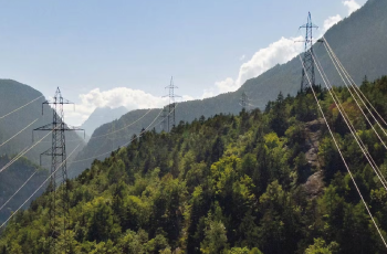
Swissgrid AG - Evaluation of ArcGIS Utility Network Usage Custom asset management system based on ArcGIS Utility Network for a future-proof high-voltage grid. learn more Read more about Swissgrid AG
Swissgrid AG - Evaluation of ArcGIS Utility Network Usage Custom asset management system based on ArcGIS Utility Network for a future-proof high-voltage grid. learn more
Digital real estate valuation on the Ecclesia GIS platform Efficient and customer-orientated processes with the help of geoinformation learn more Read more about Digital real estate valuation on the Ecclesia GIS platform
Digital real estate valuation on the Ecclesia GIS platform Efficient and customer-orientated processes with the help of geoinformation learn more
Vodafone - Automated Processing of Mobile Network Geodata Reliable and current: The geo-information about the current state of the mobile network which is generated by FME Server serves as an essential basis for many, often critical, use cases related to Vodafone’s mobile network. learn more Read more about Vodafone - Automated Processing of Mobile Network Geodata (EN) dup
Vodafone - Automated Processing of Mobile Network Geodata Reliable and current: The geo-information about the current state of the mobile network which is generated by FME Server serves as an essential basis for many, often critical, use cases related to Vodafone’s mobile network. learn more
UCD-Support in the development of the RAG time series analysis User-centred design methods help to implement intuitive usability and optimised user experience for complex requirements. learn more Read more about RAG - UCD-Unterstützung RAG Zeitreihenanalyse EN
UCD-Support in the development of the RAG time series analysis User-centred design methods help to implement intuitive usability and optimised user experience for complex requirements. learn more
WebGIS tralis With WebGIS tralis, Deutsche Funkturm has a focused, lightweight and modern web application at its disposal. WebGIS tralis focuses on the use case and adds value to the existing WebGIS infrastructure. learn more Read more about WebGIS tralis EN
WebGIS tralis With WebGIS tralis, Deutsche Funkturm has a focused, lightweight and modern web application at its disposal. WebGIS tralis focuses on the use case and adds value to the existing WebGIS infrastructure. learn more
Smart geodata management for shopping centres One of the main tasks of ECE Marketplaces GmbH & Co. KG is to organise and manage the approximately 20,000 tenants who operate stores in the various shopping centres. With the help of security.manager, GIS administration can be significantly simplified. learn more Read more about ECE Marketplaces
Smart geodata management for shopping centres One of the main tasks of ECE Marketplaces GmbH & Co. KG is to organise and manage the approximately 20,000 tenants who operate stores in the various shopping centres. With the help of security.manager, GIS administration can be significantly simplified. learn more
ICRC - Geoportal of the International Red Cross New central and user-optimised platform for the provision of diverse geodata. learn more Read more about ICRC - Geoportal of the International Red Cross
ICRC - Geoportal of the International Red Cross New central and user-optimised platform for the provision of diverse geodata. learn more
Geodata Management with Geobase Geodata are a decisive building block for numerous critical business processes in the telecommunications industry. learn more Read more about Geodata Management with Geobase
Geodata Management with Geobase Geodata are a decisive building block for numerous critical business processes in the telecommunications industry. learn more
Upgrade and Migration of ArcGIS Enterprise The migration of the ArcGIS Enterprise environment of the geoportal of the Luxembourg Cadastral and Surveying Office from version 10.6.1 to version 10.8.1 was done in productive use. learn more Read more about Upgrade and Migration ArcGIS Enterprise
Upgrade and Migration of ArcGIS Enterprise The migration of the ArcGIS Enterprise environment of the geoportal of the Luxembourg Cadastral and Surveying Office from version 10.6.1 to version 10.8.1 was done in productive use. learn more
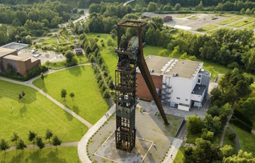
Technical information system for soil pollution in NRW (FIS StoBo) The FIS StoBo answers questions about soil pollution in North Rhine-Westphalia in a technically and simple way. learn more Read more about Technical information system for soil pollution in NRW (FIS StoBo)
Technical information system for soil pollution in NRW (FIS StoBo) The FIS StoBo answers questions about soil pollution in North Rhine-Westphalia in a technically and simple way. learn more
Concept for orienting and adapting the UBA.gdi to INSPIRE Creation of a comprehensive concept for the development of a central infrastructure node. learn more Read more about Concept for orienting and adapting the UBA.gdi to INSPIRE
Concept for orienting and adapting the UBA.gdi to INSPIRE Creation of a comprehensive concept for the development of a central infrastructure node. learn more
Speech recognition during forest surveys Voice interaction supports and optimizes the workflow during forest surveys at BIMA - Division Bundesforst. learn more Read more about BIMA Sparte Bundesforst - Speech recognition during forest surveys
Speech recognition during forest surveys Voice interaction supports and optimizes the workflow during forest surveys at BIMA - Division Bundesforst. learn more
VGV-Easy Geodata-based valuation for property insurance learn more Read more about VGV-Easy - Geodata-based valuation for property insurance
ForestCare Single tree-based, satellite-supported Forest Ecosystem Monitoring learn more Read more about ForestCare – Single tree-based, satellite-supported Forest Ecosystem Monitoring
Food Truck Notification Service The “Greenhouse App” is based on map.apps and FME Server technology. It enables registration for one of the food truck‘s digitized stops. learn more Read more about Food Truck Notification Service
Food Truck Notification Service The “Greenhouse App” is based on map.apps and FME Server technology. It enables registration for one of the food truck‘s digitized stops. learn more
ForstGIS NRW – The platform for on and offline apps Within a short space of time, the Web GIS platform ForstGIS NRW from Wald und Holz NRW enabled the efficient realisation of a range of specialist apps, which the Administration implemented either itself or in a joint development project with con terra. learn more Read more about ForstGIS NRW - The platform for on and offline apps
ForstGIS NRW – The platform for on and offline apps Within a short space of time, the Web GIS platform ForstGIS NRW from Wald und Holz NRW enabled the efficient realisation of a range of specialist apps, which the Administration implemented either itself or in a joint development project with con terra. learn more
FGIS_online - Forest Web GIS The web GIS platform FGIS_online is designed to enable the efficient creation of appropriately focused apps for supporting the tasks of the Sachsenforst state forestry service. learn more Read more about FGIS_online Forstliches Web GIS
FGIS_online - Forest Web GIS The web GIS platform FGIS_online is designed to enable the efficient creation of appropriately focused apps for supporting the tasks of the Sachsenforst state forestry service. learn more
Geo Data Management with FME Desktop at DEA Since the introduction of FME, the number of use cases at DEA has increased continuously. learn more Read more about Geo Data Management with FME Desktop at DEA
Geo Data Management with FME Desktop at DEA Since the introduction of FME, the number of use cases at DEA has increased continuously. learn more
User-centered redesign The objective is to more easily integrate the open geodata from GEOportal.NRW and establish the mutual exchange with the Open.NRW portal. learn more Read more about User-centered redesign
User-centered redesign The objective is to more easily integrate the open geodata from GEOportal.NRW and establish the mutual exchange with the Open.NRW portal. learn more
User-centered Design for the mCLOUD Open Data Portal The results of the UCD workshop flow into the user-centered and sustainable further development of the mCLOUD as important decision aids. learn more Read more about User-Centered Design for the mCLOUD Open Data Portal
User-centered Design for the mCLOUD Open Data Portal The results of the UCD workshop flow into the user-centered and sustainable further development of the mCLOUD as important decision aids. learn more
Earth Observation Web Services UX Design Support For optimum user experience it is important to record the actual users as fully and correctly as possible in order to be able to undertake optimization on that basis. learn more Read more about Earth Observation Web Services UX Design Support
Earth Observation Web Services UX Design Support For optimum user experience it is important to record the actual users as fully and correctly as possible in order to be able to undertake optimization on that basis. learn more
BORISplus.NRW App Easy to use mobile application for querying and displaying standard land values in NRW. learn more Read more about BORISplus.NRW App
BORISplus.NRW App Easy to use mobile application for querying and displaying standard land values in NRW. learn more
Digital Radio Reception Forecast Tool Easy-to-use reception forecast tool for providing precise location-based information. learn more Read more about Digital Radio Reception Forecast Tool
Digital Radio Reception Forecast Tool Easy-to-use reception forecast tool for providing precise location-based information. learn more
Earth Observation Portal Central portal for accessing EUMETSAT data. learn more Read more about Earth Observation Portal
Transformation of terrestrial LiDAR for urban inventories FME Desktop was used to efficiently transform point cloud data into surface models as part of an urban inventory project. learn more Read more about Transformation of terrestrial LiDAR for urban inventories
Transformation of terrestrial LiDAR for urban inventories FME Desktop was used to efficiently transform point cloud data into surface models as part of an urban inventory project. learn more
SITMUN: an SDI for municipal management FME Desktop and FME Server were used to design an SDI that incorporates interoperability, validation and geographic information processing features in a web environment for facilitating municipal management. learn more Read more about SITMUN: an SDI for municipal management
SITMUN: an SDI for municipal management FME Desktop and FME Server were used to design an SDI that incorporates interoperability, validation and geographic information processing features in a web environment for facilitating municipal management. learn more
Stylised Vector Data in Mobile Devices A JavaScript API based on Leaflet has been developed. It is capable of showing the tiled base map, using the Mapnik technology implemented in FME, and the thematic information in vector format generated through an FME process that is periodically updated with FME Server. learn more Read more about Stylised Vector Data in Mobile Devices
Stylised Vector Data in Mobile Devices A JavaScript API based on Leaflet has been developed. It is capable of showing the tiled base map, using the Mapnik technology implemented in FME, and the thematic information in vector format generated through an FME process that is periodically updated with FME Server. learn more
Automated production of the National Topographic Map IGN has largely automated the production of the cartographic series 1:25,000 of the National Topographic Map with the help of FME technology. learn more Read more about Automated production of the National Topographic Map
Automated production of the National Topographic Map IGN has largely automated the production of the cartographic series 1:25,000 of the National Topographic Map with the help of FME technology. learn more
Generation of CityGML data FME Desktop for fast and efficient processing of 3D data. learn more Read more about Generation of CityGML data using FME Desktop
GIS in map publishing FME is employed for the purposes of managing the extensive data volume and ensuring data heterogeneity, as well as for standardising data and preparing and modifying it for the internal GIS cartographic process with ArcGIS. learn more Read more about GIS in map publishing
GIS in map publishing FME is employed for the purposes of managing the extensive data volume and ensuring data heterogeneity, as well as for standardising data and preparing and modifying it for the internal GIS cartographic process with ArcGIS. learn more
SIGcom - Local Authority WebGIS for Luxemburg Modern platform based on ArcGIS, map.apps and security.manager. learn more Read more about SIGcom - Local Authority WebGIS for Luxemburg
SIGcom - Local Authority WebGIS for Luxemburg Modern platform based on ArcGIS, map.apps and security.manager. learn more
INSPIRE data harmonization The specified INSPIRE data harmonization workflow is one of the first solutions which describes the complete process from existing data to the annex I theme “protected sites”. learn more Read more about INSPIRE data harmonization
INSPIRE data harmonization The specified INSPIRE data harmonization workflow is one of the first solutions which describes the complete process from existing data to the annex I theme “protected sites”. learn more
ERGO GIS Assistance Stable and secure assistance solution, providing comprehensive support on demand. learn more Read more about ERGO GIS Assistance
ERGO GIS Assistance Stable and secure assistance solution, providing comprehensive support on demand. learn more
GeoBAK 2.0 Provision of a central platform for the publication of standards-compliant (OGC and INSPIRE) spatial services. learn more Read more about GeoBAK 2.0
GeoBAK 2.0 Provision of a central platform for the publication of standards-compliant (OGC and INSPIRE) spatial services. learn more
Digital Service File Information and integration platform for data with spatial references. learn more Read more about Digital Service File
Digital Service File Information and integration platform for data with spatial references. learn more
An operations management system that combines GIS and SAP-ERP With the OMS, the core of a modern IT infrastructure was established in the Emschergenossenschaft and Lippeverband on the basis of an SOA. learn more Read more about An operations management system that combines GIS & SAP-ERP
An operations management system that combines GIS and SAP-ERP With the OMS, the core of a modern IT infrastructure was established in the Emschergenossenschaft and Lippeverband on the basis of an SOA. learn more
3D System Building Restricted Areas The application makes a significant contribution to approval procedures relating to building structures within a CNS facility’s building restricted area pursuant to § 18a LuftVG. learn more Read more about 3D System Building Restricted Areas
3D System Building Restricted Areas The application makes a significant contribution to approval procedures relating to building structures within a CNS facility’s building restricted area pursuant to § 18a LuftVG. learn more
Cumulative Claims Management System Cumulative events can now be quickly and simply modelled and fed into the claims system. learn more Read more about Cumulative Claims Management System
Cumulative Claims Management System Cumulative events can now be quickly and simply modelled and fed into the claims system. learn more
Land registry for green spaces and playgrounds A green-space and playground registry solution to form the basis for optimising further business processes. learn more Read more about Land registry for green spaces and playgrounds
Land registry for green spaces and playgrounds A green-space and playground registry solution to form the basis for optimising further business processes. learn more
Winter Maintenance Management System With the WDMS-BY, it has been possible to create a solution based on a variety of data in conjunction with appropriate equipment, which, despite the complexity of the assignment, is not only easy to use but gives precise assistance to winter road maintenance services. learn more Read more about Winter Maintenance Management System
Winter Maintenance Management System With the WDMS-BY, it has been possible to create a solution based on a variety of data in conjunction with appropriate equipment, which, despite the complexity of the assignment, is not only easy to use but gives precise assistance to winter road maintenance services. learn more