GeoAI
Optimised geodata use with artificial intelligence
By integrating custom-fit AI components into your GeoIT infrastructure, you can optimise processes, gain targeted information and make smarter decisions.
con terra’s GeoAI experts will support you in this task – from the development of initial project ideas, to the integration of AI into your processes and the monitoring of success.

Artificial Intelligence (AI) is becoming an increasingly crucial factor in future-proofing infrastructures. Especially when dealing with geodata, the use of artificial intelligence can significantly simplify your work and processes. Thanks to our many years of experience as a GeoIT integrator, we know where GeoAI can be used to optimise highly complex workflows, uncover hidden patterns, or gain new insights. For us, GeoAI is not a trendy word. For us, it is an option to significantly simplify your processes – and only if it shows real benefits.
GeoAI by con terra
Our range of services is individual and comprehensive: Together with you, we develop suitable approaches and analysis procedures, select tools and determine the appropriate AI measures that will take your geodata use to a new level. From the development of initial project approaches to monitoring of success – with us, GeoAI is used precisely when it provides you with true added value. It is important that we do not fundamentally change established processes, but rather optimise them in a targeted way by the needs-oriented use of GeoAI.
Our products and services
GeoAI Discovery: Individual analysis of needs and potential
Development of concepts and proof of concepts
Flexible integration into your business processes
Monitoring and support
Count on our experience
The selection of appropriate AI measures is not the only factor responsible for the success of a GeoAI project. Comprehensive data processing is especially crucial. As a long-standing partner of Safe Software, manufacturer of the FME platform, reliable data management is one of our core competencies. Rely on our experience in the field of GeoIT integration and benefit from our expertise.
Data preparation: We harmonise your data sources and formats and make them usable for AI methods.
AI methods: From voice control to deep learning methods, we have different technologies in use.
Integration and operation: As a GeoIT integrator, we have many years of experience in designing custom-fit solutions.
Visualisation and application: Platform-independent, userfriendly, individual — our solutions are tailored to your needs.
Application possibilities of GeoAI
Artificial intelligence can be used to support many areas of data processing. For example, the use of voice control helps optimise tasks that require free hands. Automatic image recognition speeds up tedious mapping tasks, whereas deep learning models are used to uncover complex relationships between data. In our projects, we have already been able to use artificial intelligence profitably in various ways. We distinguish between four different deployment methods:
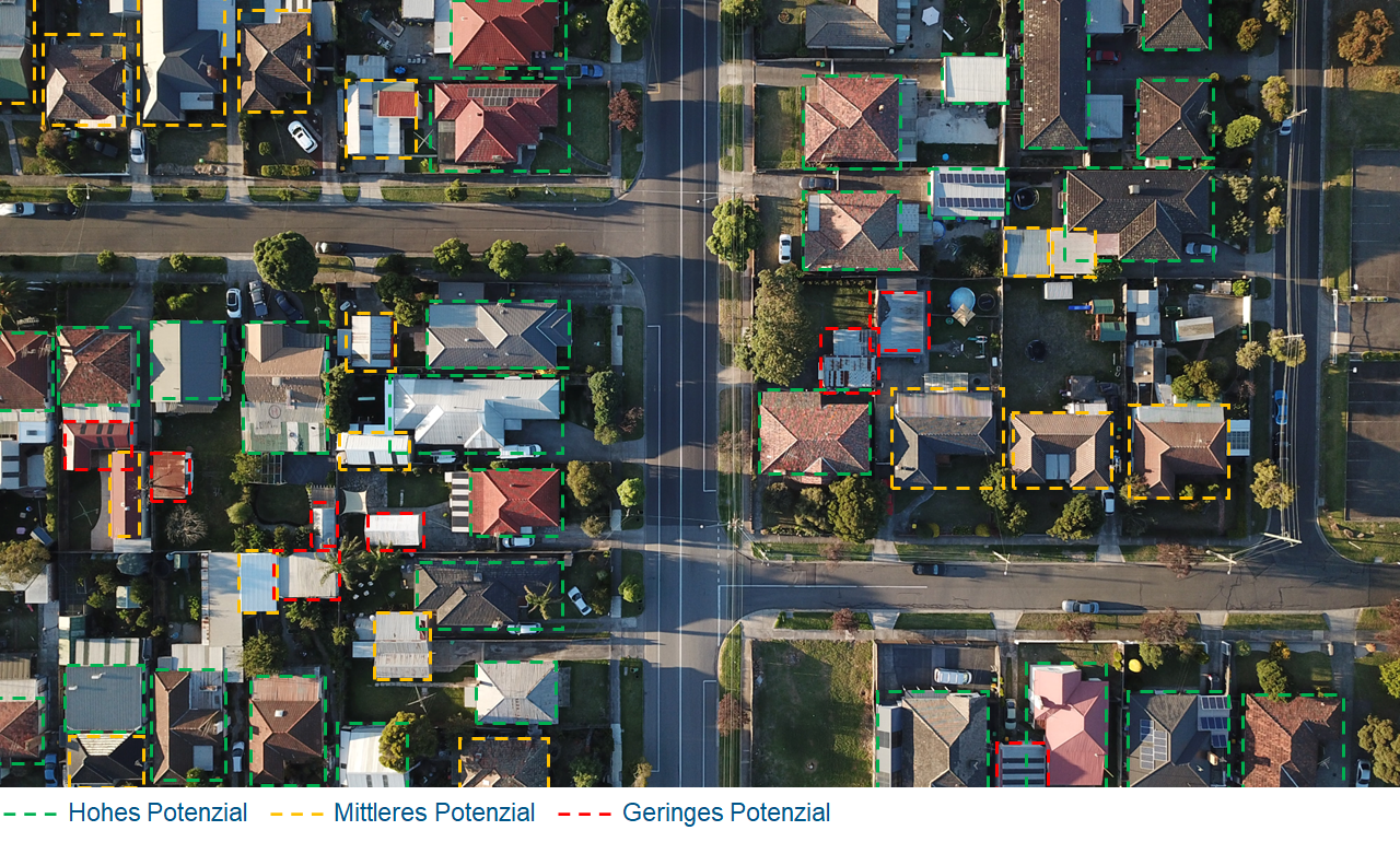
Image and Object Recognition
In the field of image recognition, GeoAI methods can be used to locate objects e.g. in aerial or satellite images. Algorithms can also be used e.g. to automatically digitize drawings.
Natural Language Processing
One achievement that was only made possible through the use of AI algorithms is the productive processing of natural language. This makes it possible, for instance, to control apps by voice input or to translate and analyze handwritten texts.

This enables employees in forestry operations to record trees by voice so that they do not have to constantly switch between measuring tools and recording devices (e.g. tablets). This makes work run more smoothly and relieves the strain on employees.
Smart search and archiving for digital documents
In many cases, important documents such as construction plans are available either in paper form or as scanned files. Depending on how well they are named or their filing structure, they are often difficult to research and find. If filing structures have grown over time, the naming of documents can change. Viewing the data then becomes extremely time-consuming for users, especially if this is only possible by opening each individual file.
GeoAI helps!
Usually, digital documents contain information that describes them very well: Headings, location details, editors, short descriptions, references, etc.
With FME and GeoAI, we are able to search even very large-format documents, detect text elements and store relevant information in a database.
In this way, we can quickly and automatically make your database easily and accurately searchable for all user groups, even if no corresponding metadata is yet available.
Are you interested in the use case or the service? Please contact us by e-mail at: geoai@conterra.de.
Data Enhancement
The volume of available data worldwide is increasing by billions of terabytes every year. However, much of this data contains gaps or errors that are difficult to detect. AI can help to quickly and automatically ensure the data quality e.g. of sensor data.

Forecasting
AI algorithms prove their strength particularly in dynamic and complex systems with highly diverse data. For example, in weather-dependent systems with other multiple influencing factors, reliable and stable forecasts can be made for local events.

For the prediction of pest populations in forestry operations, localized warnings for the summer months could already be issued in spring. This means that staff can be deployed in a more targeted and better oriented manner.


GeoAI Flyer